Dryness and drought are again tightening their grip on the central Plains, sharpening concern for the U.S. Hard Red Winter wheat crop as it breaks dormancy.
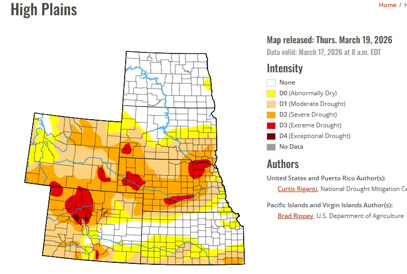
The U.S. drought monitor released Thursday said drought worsened in southwest Kansas and southeast Colorado in the week ended March 17, as precipitation deficits continued to mount amid a lack of rain and warmer-than-normal temperatures this winter and early spring.
While eastern Kansas saw some localized improvement earlier in March after heavier rain, drought of varying intensity still stretches across much of the central Great Plains. According to the drought monitor, almost one quarter of the top winter wheat production state of Kansas was being impacted by some form of drought as of Tuesday, up from around 15.5% a week earlier.
But the problem is broader in nearby states, with almost 70% of Colorado and 94% of Oklahoma in some form of drought, underscoring how much of the Hard Red Winter wheat belt remains moisture stressed. Meanwhile, dryness is also taking a heavy toll farther north in Nebraska, where wind-driven wildfires have burned across more than 700,000 acres of farmland.
Kansas crop ratings show that stress has been building through the winter. In its final national crop progress report for the 2025 growing season, the USDA pegged the Kansas winter wheat crop at 62% good to excellent as of Nov. 23. That rating gradually ticked lower through the winter months, with the latest state report putting the crop at 52% good to excellent as of Sunday. That is still above last year’s rating of 49% good to excellent, but this year’s downward trend is clear.
Kansas soil moisture has deteriorated at the same time: topsoil rated short to very short climbed from 18% in early December to 35% in early February and then 48% by mid-March, while subsoil short to very short rose from 26% to 37% and then 48%.
Meanwhile, the near-term forecast offers little immediate relief. According to World Weather, a potentially historic warm-up is underway across the region, with temperatures on Friday and Saturday expected to reach record-breaking levels for late March, followed by more unusual heat around the middle of next week.
The strong high-pressure ridge driving the heat is also keeping conditions dry, with no meaningful rain expected through Wednesday and little to none likely from March 26 to 28. Rain chances may improve somewhat between March 29 and April 2, especially in eastern areas, World Weather said.